
Trail System
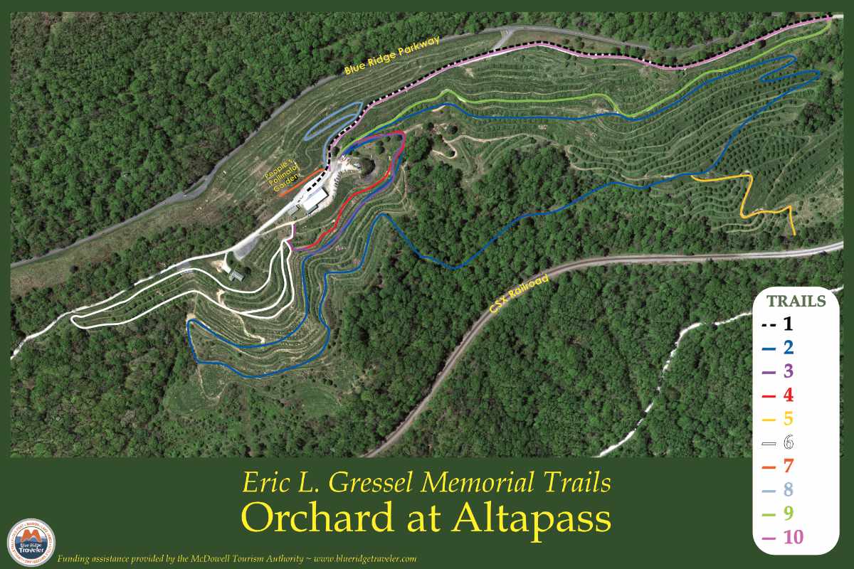
The above map was created from an aerial view of the Orchard. Although comprehensive, the actual Orchard extends several acres on either side of the image. Please refer to the map for guidance only. Trails may move with changing weather conditions, new plantings, and field restrictions.
Trails are color-coded, as shown below. The directions include the approximate length and difficulty—stroller-friendly trails are indicated.
Maps are also available at the foundation station in the red barn and the Apple Shed below and behind the barn.
Trail 1
The state-maintained Orchard Road flanking the Orchard.
Difficulty: Easy
Difficulty: Easy
Trail 2
The longest designated trail at the Orchard; leads through the woods & highlights two small waterfalls that travel through the original stone arch below the bridges.
Length: 3 miles
Difficulty: Hard (length, landscape gradient, forested)
Length: 3 miles
Difficulty: Hard (length, landscape gradient, forested)
Trail 3
Begins at the main trailhead & ends on the opposite side of the pavilion; leads through a wooded section & extends into the front of the property.
Length: 1½ miles
Difficulty: Moderate (forested, relatively level, quick gradient change/stairs at end)
Length: 1½ miles
Difficulty: Moderate (forested, relatively level, quick gradient change/stairs at end)
Trail 4
Mimics Trail 3. one row above.
Length: 1½ miles
Difficulty: Moderate (forested, relatively level, quick gradient change/stairs at end)
Length: 1½ miles
Difficulty: Moderate (forested, relatively level, quick gradient change/stairs at end)
Trail 5
Accessed through Trail 2. It takes you to the Orchard’s oldest transportation route-Clinchfield railway transported tons of apples across the country.
Length: 2½ miles
Difficulty: Moderate (length, grassy, gradient change)
Length: 2½ miles
Difficulty: Moderate (length, grassy, gradient change)
Trail 6
Upper & lower begin on the opposite side of the pavilion & continue towards the house.
Length: upper: 1½ miles, lower: 2 miles
Difficulty: Moderate (length, occasional dips in the trail, grassy; the upper trail is steep near trails end)
Length: upper: 1½ miles, lower: 2 miles
Difficulty: Moderate (length, occasional dips in the trail, grassy; the upper trail is steep near trails end)
Trail 7
Leads to the People’s Pollinator Garden (PPG) featuring pollinator-friendly and energy-revitalizing plants.
Length: ¼ mile
Difficulty: Moderate (length, incline, grassy)
Length: ¼ mile
Difficulty: Moderate (length, incline, grassy)
Trail 8
To the right of Trail 7, loops around the Orchard above the barn.
Length: ½ mile
Difficulty: Moderate (length, incline) *stroller friendly
Length: ½ mile
Difficulty: Moderate (length, incline) *stroller friendly
Trail 9
Begins at the main trailhead; ends midway down Orchard Road towards Trail 10. Used as “heyride” route.
Length: 2 miles
Difficulty: Moderate (length, incline) *stroller friendly
Length: 2 miles
Difficulty: Moderate (length, incline) *stroller friendly
Trail 10
Leads to the Charlie Mckinney & family gravesites.
Length: 1 mile on Orchard Road. ½ mile downstairs
Difficulty: Easy length. stair incline and decline from stairs ) +NOT stroller friendly
Length: 1 mile on Orchard Road. ½ mile downstairs
Difficulty: Easy length. stair incline and decline from stairs ) +NOT stroller friendly
In early 2012, Bill and Judy Carson gathered a team of experts in trail building, graphic design, and the natural and cultural history of the Orchard at Altapass. Together they designed a trail network that would wind through the rows of apple trees and adjacent mountain cove forest overlooking the “high pass” for which Altapass was named. The project was made possible by funding from the Blue Ridge National Heritage Area, Progress Energy, and contributions in memory of Eric L. Gressel, a long-time Orchard volunteer.
